
Make a donation
Gear up for your next adventure:
As an Amazon Associate, this site earns from qualifying purchases at no extra cost to you.
Champeau topographic map
Click on the map to display elevation.
Make a donation
Gear up for your next adventure:
As an Amazon Associate, this site earns from qualifying purchases at no extra cost to you.
About this map
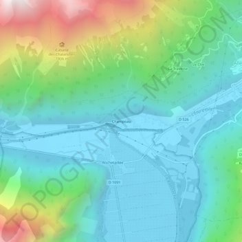
Name: Champeau topographic map, elevation, terrain.
Average elevation: 3,652 ft
Minimum elevation: 2,306 ft
Maximum elevation: 7,779 ft
Make a donation
Gear up for your next adventure:
As an Amazon Associate, this site earns from qualifying purchases at no extra cost to you.
Other topographic maps
Click on a map to view its topography, its elevation and its terrain.
Lac du Verney
France > Auvergne-Rhône-Alpes > Isère > Allemond
Le lac du Verney s'étend sur 75 ha à 725 mètres d'altitude et a une profondeur variable. Il est situé entre les massifs de Belledonne et des Grandes Rousses et proche des communes d’Allemond, d'Oz-en-Oisans et de Vaujany.
Average elevation: 3,307 ft