
Thank you for supporting this site ❤️
Make a donation
Make a donation
Gear up for your next adventure:
As an Amazon Associate, this site earns from qualifying purchases at no extra cost to you.
Mont-ral topographic map
Click on the map to display elevation.
Thank you for supporting this site ❤️
Make a donation
Make a donation
Gear up for your next adventure:
As an Amazon Associate, this site earns from qualifying purchases at no extra cost to you.
About this map
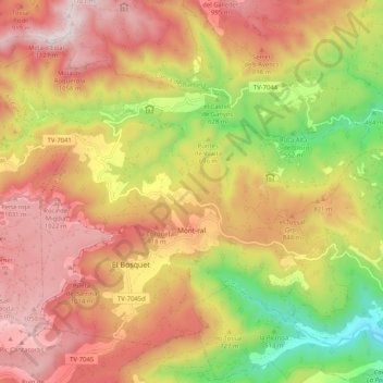
Name: Mont-ral topographic map, elevation, terrain.
Location: Mont-ral, Alt Camp, Tarragona, Catalonia, 43364, Spain (41.26379 1.04287 41.32606 1.14576)
Average elevation: 2,428 ft
Minimum elevation: 876 ft
Maximum elevation: 3,688 ft
Thank you for supporting this site ❤️
Make a donation
Make a donation
Gear up for your next adventure:
As an Amazon Associate, this site earns from qualifying purchases at no extra cost to you.
Other topographic maps
Click on a map to view its topography, its elevation and its terrain.
Tossal de la Serra del Mas de Gomis
Spain > Catalonia > Alt Camp > Alcover
Average elevation: 2,169 ft