
Make a donation
Gear up for your next adventure:
As an Amazon Associate, this site earns from qualifying purchases at no extra cost to you.
Olperer topographic map
Click on the map to display elevation.
Make a donation
Gear up for your next adventure:
As an Amazon Associate, this site earns from qualifying purchases at no extra cost to you.
Olperer
L'Olperer est une montagne qui s'élève à 3 476 m d'altitude dans les Alpes de Zillertal en Autriche. Sur sa face nord, elle domine le glacier de Hintertux.
Make a donation
Gear up for your next adventure:
As an Amazon Associate, this site earns from qualifying purchases at no extra cost to you.
About this map
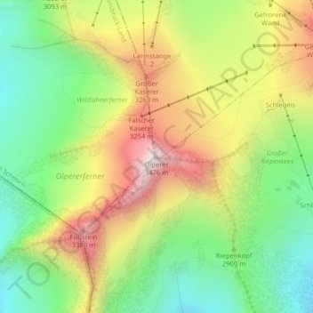
Name: Olperer topographic map, elevation, terrain.
Location: Olperer, Tux, Bezirk Schwaz, Tyrol, Autriche (47.05326 11.65867 47.05336 11.65877)
Average elevation: 9,629 ft
Minimum elevation: 8,350 ft
Maximum elevation: 11,306 ft
Make a donation
Gear up for your next adventure:
As an Amazon Associate, this site earns from qualifying purchases at no extra cost to you.