
Make a donation
Gear up for your next adventure:
As an Amazon Associate, this site earns from qualifying purchases at no extra cost to you.
Baldham topographic map
Click on the map to display elevation.
Make a donation
Gear up for your next adventure:
As an Amazon Associate, this site earns from qualifying purchases at no extra cost to you.
Baldham
Die Kolonie Baldham wurde vor Beginn des Zweiten Weltkriegs als Standort für das Atelier von Hitlers Bildhauer Josef Thorak gewählt. Das von Albert Speer zwischen 1938 und 1941 errichtete Gebäude (heute Waldstraße 17) besteht aus einem zentralen Baukörper mit einer Höhe von 18 Meter und einer Grundfläche von 700 m². An der Frontseite öffnen sich drei gewaltige Tore von 11,8 m Höhe, die den Monumentalstatuen Durchgang gewähren sollten. Die drei anderen Seiten des Zentralbaus sind von einem niedrigen Anbau umschlossen.
Make a donation
Gear up for your next adventure:
As an Amazon Associate, this site earns from qualifying purchases at no extra cost to you.
About this map
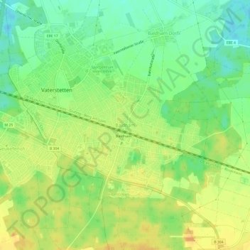
Name: Baldham topographic map, elevation, terrain.
Average elevation: 1,795 ft
Minimum elevation: 1,742 ft
Maximum elevation: 1,841 ft
Make a donation
Gear up for your next adventure:
As an Amazon Associate, this site earns from qualifying purchases at no extra cost to you.
Other topographic maps
Click on a map to view its topography, its elevation and its terrain.
85598
Deutschland > Bayern > Landkreis Ebersberg > Vaterstetten > Baldham Dorf
Average elevation: 1,778 ft