
Thank you for supporting this site ❤️
Make a donation
Make a donation
Gear up for your next adventure:
As an Amazon Associate, this site earns from qualifying purchases at no extra cost to you.
Teldeniya topographic map
Click on the map to display elevation.
Thank you for supporting this site ❤️
Make a donation
Make a donation
Gear up for your next adventure:
As an Amazon Associate, this site earns from qualifying purchases at no extra cost to you.
About this map
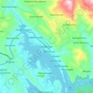
Name: Teldeniya topographic map, elevation, terrain.
Location: Teldeniya, Kandy District, Central Province, 20900, Sri Lanka (7.26964 80.72495 7.34964 80.80495)
Average elevation: 1,972 ft
Minimum elevation: 1,362 ft
Maximum elevation: 4,229 ft
Thank you for supporting this site ❤️
Make a donation
Make a donation
Gear up for your next adventure:
As an Amazon Associate, this site earns from qualifying purchases at no extra cost to you.