
Thank you for supporting this site ❤️
Make a donation
Make a donation
Gear up for your next adventure:
As an Amazon Associate, this site earns from qualifying purchases at no extra cost to you.
Giacchini topographic map
Click on the map to display elevation.
Thank you for supporting this site ❤️
Make a donation
Make a donation
Gear up for your next adventure:
As an Amazon Associate, this site earns from qualifying purchases at no extra cost to you.
About this map
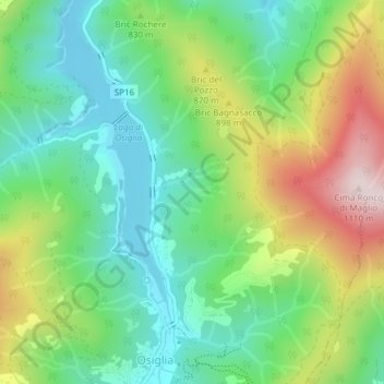
Name: Giacchini topographic map, elevation, terrain.
Location: Giacchini, Ca' nove, Osiglia, Savona, Liguria, Italia (44.28441 8.19579 44.30441 8.21579)
Average elevation: 2,585 ft
Minimum elevation: 2,034 ft
Maximum elevation: 3,606 ft
Thank you for supporting this site ❤️
Make a donation
Make a donation
Gear up for your next adventure:
As an Amazon Associate, this site earns from qualifying purchases at no extra cost to you.