
Thank you for supporting this site ❤️
Make a donation
Make a donation
Gear up for your next adventure:
As an Amazon Associate, this site earns from qualifying purchases at no extra cost to you.
Le Rousseau topographic map
Click on the map to display elevation.
Thank you for supporting this site ❤️
Make a donation
Make a donation
Gear up for your next adventure:
As an Amazon Associate, this site earns from qualifying purchases at no extra cost to you.
About this map
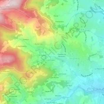
Name: Le Rousseau topographic map, elevation, terrain.
Average elevation: 1,578 ft
Minimum elevation: 1,007 ft
Maximum elevation: 2,569 ft
Thank you for supporting this site ❤️
Make a donation
Make a donation
Gear up for your next adventure:
As an Amazon Associate, this site earns from qualifying purchases at no extra cost to you.
Other topographic maps
Click on a map to view its topography, its elevation and its terrain.
Vaugneray
France > Auvergne-Rhône-Alpes > Rhône > Vaugneray
Enfin, on notera utilement les références topographique à la commune dans le fichier topographique de Marguerite Gonon.
Average elevation: 1,470 ft