
Thank you for supporting this site ❤️
Make a donation
Make a donation
Gear up for your next adventure:
As an Amazon Associate, this site earns from qualifying purchases at no extra cost to you.
Mangunsari topographic map
Click on the map to display elevation.
Thank you for supporting this site ❤️
Make a donation
Make a donation
Gear up for your next adventure:
As an Amazon Associate, this site earns from qualifying purchases at no extra cost to you.
About this map
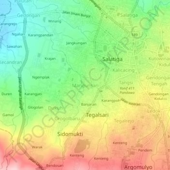
Name: Mangunsari topographic map, elevation, terrain.
Location: Mangunsari, Salatiga, Central Java, Java, 50721, Indonesia (-7.35648 110.47307 -7.31648 110.51307)
Average elevation: 1,942 ft
Minimum elevation: 1,617 ft
Maximum elevation: 2,336 ft
Thank you for supporting this site ❤️
Make a donation
Make a donation
Gear up for your next adventure:
As an Amazon Associate, this site earns from qualifying purchases at no extra cost to you.
Other topographic maps
Click on a map to view its topography, its elevation and its terrain.
Gantangan Burung Bung Karno Dukuh Salatiga
Indonesia > Central Java > Salatiga > Dukuh > Glogolan
Average elevation: 1,965 ft