
Make a donation
Gear up for your next adventure:
As an Amazon Associate, this site earns from qualifying purchases at no extra cost to you.
Caraquiz topographic map
Click on the map to display elevation.
Make a donation
Gear up for your next adventure:
As an Amazon Associate, this site earns from qualifying purchases at no extra cost to you.
About this map
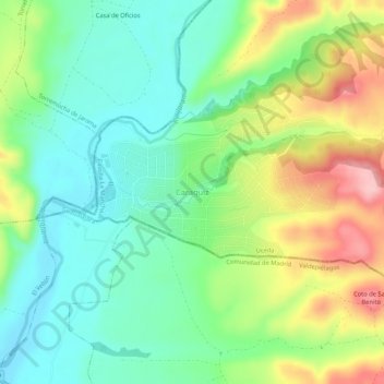
Name: Caraquiz topographic map, elevation, terrain.
Location: Caraquiz, Uceda, Guadalajara, Castile-La Mancha, 28170, Spain (40.77140 -3.50916 40.81140 -3.46916)
Average elevation: 2,339 ft
Minimum elevation: 2,139 ft
Maximum elevation: 2,697 ft
Make a donation
Gear up for your next adventure:
As an Amazon Associate, this site earns from qualifying purchases at no extra cost to you.
Other topographic maps
Click on a map to view its topography, its elevation and its terrain.
Cuenca
The climate of Cuenca is the typical hot-summer Mediterranean climate of Spain's "Meseta" (inner plateau). Winters are relatively cold, but summers are quite hot during the day with occasional cool nights. Spring and autumn seasons are short, with pleasant temperatures during the day but with rather cold…
Average elevation: 3,688 ft
Make a donation
Gear up for your next adventure:
As an Amazon Associate, this site earns from qualifying purchases at no extra cost to you.
Ciudad Real
The city has a cold semi-arid climate (Köppen: BSk), with cool winters (due to its altitude) and hot to very hot dry summers. Like many other cities of Castilla-La-Mancha, the precipitation is limited throughout the year. It has one of the highest annual temperature ranges in the Iberian Peninsula, exceeding…
Average elevation: 2,067 ft
Make a donation
Gear up for your next adventure:
As an Amazon Associate, this site earns from qualifying purchases at no extra cost to you.
Cuenca
The climate of Cuenca is the typical hot-summer Mediterranean climate of Spain's "Meseta" (inner plateau). Winters are relatively cold, but summers are quite hot during the day with occasional cool nights. Spring and autumn seasons are short, with pleasant temperatures during the day but with rather cold…
Average elevation: 3,688 ft
Make a donation
Gear up for your next adventure:
As an Amazon Associate, this site earns from qualifying purchases at no extra cost to you.
Make a donation
Gear up for your next adventure:
As an Amazon Associate, this site earns from qualifying purchases at no extra cost to you.
Make a donation
Gear up for your next adventure:
As an Amazon Associate, this site earns from qualifying purchases at no extra cost to you.
Make a donation
Gear up for your next adventure:
As an Amazon Associate, this site earns from qualifying purchases at no extra cost to you.
Make a donation
Gear up for your next adventure:
As an Amazon Associate, this site earns from qualifying purchases at no extra cost to you.
Make a donation
Gear up for your next adventure:
As an Amazon Associate, this site earns from qualifying purchases at no extra cost to you.
Make a donation
Gear up for your next adventure:
As an Amazon Associate, this site earns from qualifying purchases at no extra cost to you.
Ciudad Real
The province of Ciudad Real is located in central Spain and is the third largest province in the country with an area of 19,813 km2 (7,650 sq mi). To the north lies the Province of Toledo, to the northeast the Province of Cuenca, to the east the Province of Albacete, to the south lie the Provinces of Córdoba…
Average elevation: 2,241 ft
Villarrobledo
Villarrobledo is located in the center of La Mancha, a Spanish region with approximately 26.000 km2 of almost perfect plain, on the eastern half of the Submeseta Meridional with elevation between 600 and 800 meters above sea level, and bordered by the Montes de Toledo, Sierra Morena, Sierra de Alcaraz and…
Average elevation: 2,536 ft
Make a donation
Gear up for your next adventure:
As an Amazon Associate, this site earns from qualifying purchases at no extra cost to you.
Make a donation
Gear up for your next adventure:
As an Amazon Associate, this site earns from qualifying purchases at no extra cost to you.
Make a donation
Gear up for your next adventure:
As an Amazon Associate, this site earns from qualifying purchases at no extra cost to you.
Make a donation
Gear up for your next adventure:
As an Amazon Associate, this site earns from qualifying purchases at no extra cost to you.
Guadalajara
Chosen as settlement on the basis of defensive purposes, the historic urban core of the city lies on a small elevation near the left-bank of the Henares River, also enclosed to the East and West by two small ditches corresponding to two watercourses, Alamín [es] and San Antonio, respectively, forming a narrow…
Average elevation: 2,631 ft
Make a donation
Gear up for your next adventure:
As an Amazon Associate, this site earns from qualifying purchases at no extra cost to you.
Make a donation
Gear up for your next adventure:
As an Amazon Associate, this site earns from qualifying purchases at no extra cost to you.
Make a donation
Gear up for your next adventure:
As an Amazon Associate, this site earns from qualifying purchases at no extra cost to you.
Make a donation
Gear up for your next adventure:
As an Amazon Associate, this site earns from qualifying purchases at no extra cost to you.
La Roda
The extensive municipal area features a flat terrain characteristic of the La Mancha Alta Albaceteña region. It is situated 716 meters (2349 feet) above sea level, with the southwestern edge of the municipality reaching higher elevations (over 850 meters, 2788 feet) near the Campo de Montiel.
Average elevation: 2,375 ft
Make a donation
Gear up for your next adventure:
As an Amazon Associate, this site earns from qualifying purchases at no extra cost to you.
Make a donation
Gear up for your next adventure:
As an Amazon Associate, this site earns from qualifying purchases at no extra cost to you.
Make a donation
Gear up for your next adventure:
As an Amazon Associate, this site earns from qualifying purchases at no extra cost to you.
Make a donation
Gear up for your next adventure:
As an Amazon Associate, this site earns from qualifying purchases at no extra cost to you.
Molina de Aragón
Molina de Aragón has a warm-summer mediterranean climate (Köppen climate classification: Csb) with some semi-arid influences. Precipitation is irregular throughout the year, with most rainfall occurring during spring and autumn. Winters are cold for Spanish standards, with temperatures often below 0 °C (32…
Average elevation: 3,816 ft
Make a donation
Gear up for your next adventure:
As an Amazon Associate, this site earns from qualifying purchases at no extra cost to you.
Make a donation
Gear up for your next adventure:
As an Amazon Associate, this site earns from qualifying purchases at no extra cost to you.
Make a donation
Gear up for your next adventure:
As an Amazon Associate, this site earns from qualifying purchases at no extra cost to you.
Make a donation
Gear up for your next adventure:
As an Amazon Associate, this site earns from qualifying purchases at no extra cost to you.