
Wellsville topographic map
Interactive map
Click on the map to display elevation.
Wellsville
International and regional weather reports are often misleading when Wellsville's weather is reported. Meteorologists including the National Oceanic and Atmospheric Administration (NOAA) gather their weather data of the Wellsville area from meteorological devices located at the airport, at an elevation of 2,150 feet (660 m) above sea level. The village of Wellsville is at 1,500 feet (460 m), 650 feet (200 m) lower and protected from the winds in the Genesee River Valley. Wind speeds and temperature, as well as precipitation often differ greatly, especially in the spring and the fall, between the village and the top of the mountain where the airport is located (northeast leg of Niles Hill). Sometimes the temperature varies 10 °F (−12 °C) between the village and the tops of the surrounding hills.
About this map
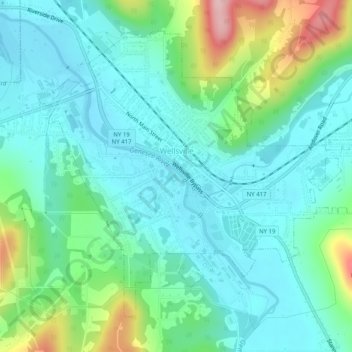
Name: Wellsville topographic map, elevation, terrain.
Location: Wellsville, Allegany County, New York, United States (42.10391 -77.96853 42.13468 -77.91818)
Average elevation: 1,634 ft
Minimum elevation: 1,467 ft
Maximum elevation: 2,165 ft
New York trails, hiking, mountain biking, running and outdoor activities