
Ongata Rongai topographic map
Click on the map to display elevation.
About this map
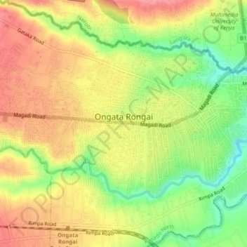
Name: Ongata Rongai topographic map, elevation, terrain.
Location: Ongata Rongai, Kajiado North, Kajiado County, 00511, Kenya (-1.40884 36.72877 -1.38527 36.76709)
Average elevation: 5,712 ft
Minimum elevation: 5,541 ft
Maximum elevation: 5,846 ft
Other topographic maps
Click on a map to view its topography, its elevation and its terrain.
Ngong
Kenya > Kajiado County > Kajiado North > Ngong ward
As of 2019, the population of Ngong Town consisting of Enchorro-Emunyi and Ngong Township locations is 25,866. The elevation of Ngong town is 1,961 meters in altitude, but the altitude of the hills is about 2,460 meters above sea level. Ngong was the central town of Ngong division while Kajiado County was a…
Average elevation: 6,401 ft
Ngong
Kenya > Kajiado County > Kajiado North > Ngong ward
As of 2019, the population of Ngong Town consisting of Enchorro-Emunyi and Ngong Township locations was 25,866. The elevation of Ngong Town is 1,961 meters in altitude, but the altitude of the hills is about 2,460 meters above sea level. Ngong was the central town of Ngong division when Kajiado County was a…
Average elevation: 6,401 ft