
Make a donation
Gear up for your next adventure:
As an Amazon Associate, this site earns from qualifying purchases at no extra cost to you.
Kessenich topographic map
Click on the map to display elevation.
Make a donation
Gear up for your next adventure:
As an Amazon Associate, this site earns from qualifying purchases at no extra cost to you.
Kessenich
… Ein angenehmer, etwa 25 Min. längerer Weg geht vom Fuße der Ruine Godesberg über die Dörfer Friesdorf an der „Amalienhöhe“ und einem Alaunwerke vorbei, über Dottendorf mit der Dottendorfer Höhe (Aussicht) und Kessenich nach Bonn. Hinter Kessenich steigt man auf einem schönen Fahrwege zur Rosenburg und zur Casselsruhe (Restauration) hinauf, wo sich ein herrliches Panorama des Rheintales und der sieben Berge eröffnet. Über den Bergrücken Venusberg führen hübsche Wege nach Poppelsdorf; von dem Schlosse rechts in 10 Min. nach Bonn.
Make a donation
Gear up for your next adventure:
As an Amazon Associate, this site earns from qualifying purchases at no extra cost to you.
About this map
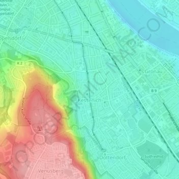
Name: Kessenich topographic map, elevation, terrain.
Average elevation: 276 ft
Minimum elevation: 138 ft
Maximum elevation: 574 ft
Make a donation
Gear up for your next adventure:
As an Amazon Associate, this site earns from qualifying purchases at no extra cost to you.
Other topographic maps
Click on a map to view its topography, its elevation and its terrain.
Bonn
Deutschland > Nordrhein-Westfalen > Bonn
Bonn hat seinen geografischen Mittelpunkt am Bundeskanzlerplatz, der sich im Ortsteil Gronau befindet. Die geografische Lage des Platzes ist 50° 43′ 8,8″ N, 7° 7′ 3,3″ O50.7191138888897.1175722222222. Die Bonner Innenstadt, die nicht zum Rhein hin ausgerichtet ist, liegt auf einer Höhe von 56 m bis 61 m ü. NHN.
Average elevation: 453 ft
Make a donation
Gear up for your next adventure:
As an Amazon Associate, this site earns from qualifying purchases at no extra cost to you.
Oberholtorf
Deutschland > Nordrhein-Westfalen > Bonn > Holtorf > Oberholtorf
Average elevation: 443 ft