
Thank you for supporting this site ❤️
Make a donation
Make a donation
Gear up for your next adventure:
As an Amazon Associate, this site earns from qualifying purchases at no extra cost to you.
Lamorteau topographic map
Click on the map to display elevation.
Thank you for supporting this site ❤️
Make a donation
Make a donation
Gear up for your next adventure:
As an Amazon Associate, this site earns from qualifying purchases at no extra cost to you.
About this map
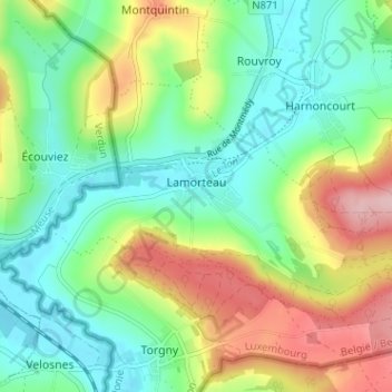
Name: Lamorteau topographic map, elevation, terrain.
Location: Lamorteau, Rouvroy, Virton, Luxembourg, Wallonie, 6767, Belgique (49.51181 5.45543 49.53774 5.51923)
Average elevation: 810 ft
Minimum elevation: 604 ft
Maximum elevation: 1,181 ft
Thank you for supporting this site ❤️
Make a donation
Make a donation
Gear up for your next adventure:
As an Amazon Associate, this site earns from qualifying purchases at no extra cost to you.