
Make a donation
Gear up for your next adventure:
As an Amazon Associate, this site earns from qualifying purchases at no extra cost to you.
Plauen topographic map
Click on the map to display elevation.
Make a donation
Gear up for your next adventure:
As an Amazon Associate, this site earns from qualifying purchases at no extra cost to you.
Plauen
Die mittlere Höhe von 412 m ü. NN ist in Plauen ein sehr theoretischer Wert, denn der tiefste Punkt ist die Elstersohle mit 305 Metern (liegt im Ortsteil Röttis), der höchste Berg ist mit 525 Metern der bewaldete Culmberg (im südlichen Stadtteil Oberlosa). Hausberg von Plauen ist der 507 Meter hohe Kemmler mit einem Bismarckturm.
Make a donation
Gear up for your next adventure:
As an Amazon Associate, this site earns from qualifying purchases at no extra cost to you.
About this map
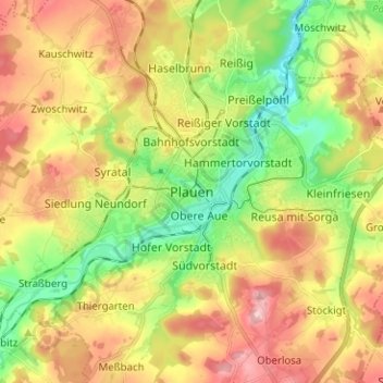
Name: Plauen topographic map, elevation, terrain.
Location: Plauen, Vogtlandkreis, Sachsen, 08523, Deutschland (50.45506 12.09465 50.53506 12.17465)
Average elevation: 1,332 ft
Minimum elevation: 1,043 ft
Maximum elevation: 1,660 ft
Make a donation
Gear up for your next adventure:
As an Amazon Associate, this site earns from qualifying purchases at no extra cost to you.