
Make a donation
Gear up for your next adventure:
As an Amazon Associate, this site earns from qualifying purchases at no extra cost to you.
Michelbach topographic map
Click on the map to display elevation.
Make a donation
Gear up for your next adventure:
As an Amazon Associate, this site earns from qualifying purchases at no extra cost to you.
Michelbach
Michelbach liegt im östlichen Hintertaunus des Naturpark Taunus in einer Höhenlage von 300 Meter bis 500 Meter über NN. Die höchste Erhebung in der Gemarkung liegt bei einer Höhe von 495 m ü. NN. Umgeben von Mischwäldern liegt das Dorf in einer Talmulde. Durch den Ort verläuft der gleichnamige Bach, der in den höher gelegenen Erhebungen entspringt.
Make a donation
Gear up for your next adventure:
As an Amazon Associate, this site earns from qualifying purchases at no extra cost to you.
About this map
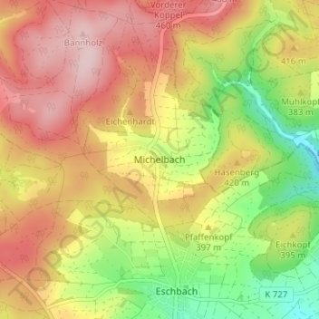
Name: Michelbach topographic map, elevation, terrain.
Location: Michelbach, Usingen, Hochtaunuskreis, Hessen, 61250, Deutschland (50.35374 8.51364 50.39374 8.55364)
Average elevation: 1,299 ft
Minimum elevation: 892 ft
Maximum elevation: 1,650 ft
Make a donation
Gear up for your next adventure:
As an Amazon Associate, this site earns from qualifying purchases at no extra cost to you.