Geolocate

Chesapeake topographic map

Click on the map to display elevation.

About this map

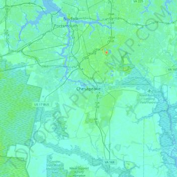
Name: Chesapeake topographic map, elevation, terrain.

Location: Chesapeake, Virginia, 23322, United States (36.55837 -76.40668 36.87837 -76.08668)

Average elevation: 16 ft

Minimum elevation: -20 ft

Maximum elevation: 135 ft

Virginia trails, hiking, mountain biking, running and outdoor activities

Other topographic maps

Click on a map to view its topography, its elevation and its terrain.

Northwest River

United States > Virginia > Chesapeake > Northwest

Average elevation: 10 ft

Bailey Creek

United States > Virginia > Chesapeake

Average elevation: 16 ft

Northwest River

United States > Virginia > Chesapeake > Northwest

Average elevation: 10 ft

Gear up for your next adventure:

🎒Gear Packing Cubes - Organize your backpack efficiently
📦Dry Bags Set - Waterproof storage for electronics and clothes
🥘Titanium Cookware - Durable, featherlight pots and pans for backpacking
🔌USB Car Charger - Car charger for on‑the‑go power needs
🧭Map Reading Tools - Tools and kits for map navigation

As an Amazon Associate, this site earns from qualifying purchases at no extra cost to you.