
Thank you for supporting this site ❤️
Make a donation
Make a donation
Gear up for your next adventure:
As an Amazon Associate, this site earns from qualifying purchases at no extra cost to you.
Saadat Shahr topographic map
Click on the map to display elevation.
Thank you for supporting this site ❤️
Make a donation
Make a donation
Gear up for your next adventure:
As an Amazon Associate, this site earns from qualifying purchases at no extra cost to you.
About this map
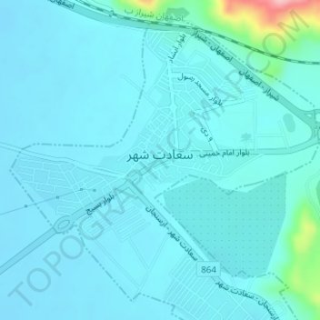
Name: Saadat Shahr topographic map, elevation, terrain.
Location: Saadat Shahr, بخش مرکزی, Pasargad County, Fars Province, Iran (30.06712 53.12117 30.09134 53.15134)
Average elevation: 5,883 ft
Minimum elevation: 5,827 ft
Maximum elevation: 6,365 ft
Thank you for supporting this site ❤️
Make a donation
Make a donation
Gear up for your next adventure:
As an Amazon Associate, this site earns from qualifying purchases at no extra cost to you.