
Make a donation
Gear up for your next adventure:
As an Amazon Associate, this site earns from qualifying purchases at no extra cost to you.
Mantagua topographic map
Click on the map to display elevation.
Make a donation
Gear up for your next adventure:
As an Amazon Associate, this site earns from qualifying purchases at no extra cost to you.
About this map
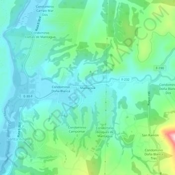
Name: Mantagua topographic map, elevation, terrain.
Average elevation: 233 ft
Minimum elevation: 26 ft
Maximum elevation: 922 ft
Make a donation
Gear up for your next adventure:
As an Amazon Associate, this site earns from qualifying purchases at no extra cost to you.
Other topographic maps
Click on a map to view its topography, its elevation and its terrain.
Humedal de Mantagua
Chile > Región de Valparaíso > Provincia de Valparaíso > Quintero > Santa Adela > Condominio Rosselot
Average elevation: 46 ft
Humedal Urbano Mantagua
Chile > Región de Valparaíso > Provincia de Valparaíso > Quintero > Santa Adela > Condominio Rosselot
Average elevation: 46 ft