Geolocate

Heath topographic map

Click on the map to display elevation.

About this map

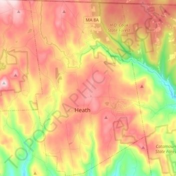
Name: Heath topographic map, elevation, terrain.

Location: Heath, Franklin County, Massachusetts, United States (42.63507 -72.86430 42.73774 -72.77265)

Average elevation: 1,457 ft

Minimum elevation: 673 ft

Maximum elevation: 2,087 ft

Other topographic maps

Click on a map to view its topography, its elevation and its terrain.

Fort Lucas

United States > Massachusetts > Franklin County

Average elevation: 876 ft

Mount Hermon

United States > Massachusetts > Franklin County > Gill

Average elevation: 325 ft

Mount Ram

United States > Massachusetts > Franklin County

Average elevation: 577 ft

Pitt Hill

United States > Massachusetts > Franklin County > Orange

Average elevation: 955 ft

Shelburne

United States > Massachusetts > Franklin County

Average elevation: 873 ft

Mount Hermon

United States > Massachusetts > Franklin County > Gill

Average elevation: 325 ft

Gear up for your next adventure:

🧦Hiking Socks - Comfortable socks to prevent blisters on long hikes
📦Gear Storage Bags - Organize and protect outdoor equipment
🔥Fast-Boil Camping Stoves - Efficient cooking systems for quick trail meals
🪶Camp Gear Gift Set - Perfect gift bundle for outdoor fans
🧯Portable Fire Pit - Compact fire pit for camping spots

As an Amazon Associate, this site earns from qualifying purchases at no extra cost to you.