
Make a donation
Gear up for your next adventure:
As an Amazon Associate, this site earns from qualifying purchases at no extra cost to you.
Markree Demesne topographic map
Click on the map to display elevation.
Make a donation
Gear up for your next adventure:
As an Amazon Associate, this site earns from qualifying purchases at no extra cost to you.
About this map
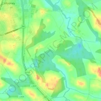
Name: Markree Demesne topographic map, elevation, terrain.
Average elevation: 121 ft
Minimum elevation: 56 ft
Maximum elevation: 207 ft
Make a donation
Gear up for your next adventure:
As an Amazon Associate, this site earns from qualifying purchases at no extra cost to you.
Other topographic maps
Click on a map to view its topography, its elevation and its terrain.
Make a donation
Gear up for your next adventure:
As an Amazon Associate, this site earns from qualifying purchases at no extra cost to you.
Make a donation
Gear up for your next adventure:
As an Amazon Associate, this site earns from qualifying purchases at no extra cost to you.
Make a donation
Gear up for your next adventure:
As an Amazon Associate, this site earns from qualifying purchases at no extra cost to you.
Easky
In Samuel Lewis's 1837 publication of A Topographical Dictionary of Ireland, Easky was described as having 6,124 inhabitants, of which 289 were in the village. Lewis noted that the village (made up of one long street) had petty sessions every fortnight and that Wednesday was market day. As well as other more…
Average elevation: 56 ft