
Make a donation
Gear up for your next adventure:
As an Amazon Associate, this site earns from qualifying purchases at no extra cost to you.
Tomayquichua topographic map
Click on the map to display elevation.
Make a donation
Gear up for your next adventure:
As an Amazon Associate, this site earns from qualifying purchases at no extra cost to you.
Tomayquichua
Tomayquichua es una localidad de Perú. Es capital del distrito de Tomay Kichwa en la provincia de Ambo, departamento de Huánuco. Se encuentra a aproximadamente 19 kilómetros de la ciudad de Huánuco y a 4,5 km de Ambo. Está a una altitud de 2041 m s. n. m.
Make a donation
Gear up for your next adventure:
As an Amazon Associate, this site earns from qualifying purchases at no extra cost to you.
About this map
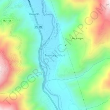
Name: Tomayquichua topographic map, elevation, terrain.
Location: Tomayquichua, Tomay Kichwa, Ambo, Huánuco, Perú (-10.09767 -76.23287 -10.05767 -76.19287)
Average elevation: 7,530 ft
Minimum elevation: 6,526 ft
Maximum elevation: 9,593 ft
Make a donation
Gear up for your next adventure:
As an Amazon Associate, this site earns from qualifying purchases at no extra cost to you.
Other topographic maps
Click on a map to view its topography, its elevation and its terrain.