Geolocate

Uberaba topographic map

Click on the map to display elevation.

About this map

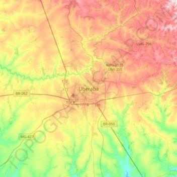
Name: Uberaba topographic map, elevation, terrain.

Location: Uberaba, Região Geográfica Imediata de Uberaba, Região Geográfica Intermediária de Uberaba, Minas Gerais, Região Sudeste, 38010030, Brasil (-19.91083 -48.09667 -19.59083 -47.77667)

Average elevation: 2,464 ft

Minimum elevation: 1,781 ft

Maximum elevation: 3,245 ft

Other topographic maps

Click on a map to view its topography, its elevation and its terrain.

Praça Rui Barbosa

Brasil > Minas Gerais > Uberaba

Average elevation: 2,543 ft

Gear up for your next adventure:

🗃️Trail First Aid Kit - Essential kit for outdoor injuries and emergencies
🌡️Handheld Weather Meters - Measure wind, temp, and pressure for safe mountain travel
🛰️Satellite Messengers - Emergency SOS and two-way messaging for off-grid adventures
📦Dry Bags Set - Waterproof storage for electronics and clothes
🪄Magnetic Compass - Accurate compass for navigation

As an Amazon Associate, this site earns from qualifying purchases at no extra cost to you.