
Lumding topographic map
Click on the map to display elevation.
Lumding
Hills of Lumding put the town a notable altitude above the sea level, but summer temperatures can reach up to 40 °C and the winters can be as chilling as 4-5 °C with fog and mist intervening in the early hours of the day. Monsoon is a notable season here, with rainfall around 60–125mm at an average. But its hills and altitude prevents any flooding in the region during heavy monsoon.
About this map
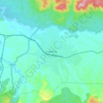
Name: Lumding topographic map, elevation, terrain.
Location: Lumding, Lanka, Hojai, Assam, 782447, India (25.71354 93.13317 25.79354 93.21317)
Average elevation: 522 ft
Minimum elevation: 358 ft
Maximum elevation: 1,273 ft