
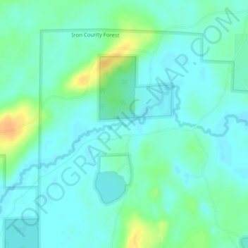
Little Turtle River topographic map
Interactive map
Click on the map to display elevation.
About this map
Name: Little Turtle River topographic map, elevation, terrain.
Average elevation: 1,601 ft
Minimum elevation: 1,572 ft
Maximum elevation: 1,673 ft
Other topographic maps
Click on a map to view its topography, its elevation and its terrain.
Wisconsin Rapids
USA > Wisconsin > Wisconsin Rapids
Wisconsin Rapids, Wood County, Wisconsin, USA
Average elevation: 1,024 ft
Harvey Creek
Harvey Creek, Buffalo County, Wisconsin, 54755, USA
Average elevation: 912 ft
Empire Praries State Natural Area - Hagen Prarie Unit
Empire Praries State Natural Area - Hagen Prarie Unit, Town of Lowville, Columbia County, Wisconsin, 53960, USA
Average elevation: 974 ft
Carroll Lake
Carroll Lake, Lindgren Road, Wills, Town of Hughes, Bayfield County, Wisconsin, USA
Average elevation: 1,201 ft
Silver Creek
Silver Creek, Town of Almon, Shawano County, Wisconsin, 54416, USA
Average elevation: 1,217 ft
Winnebago County
Town of Wolf River, Winnebago County, Wisconsin, USA
Average elevation: 758 ft
Manitoba Park
Manitoba Park, 2941, Jackson Park, Milwaukee, Milwaukee County, Wisconsin, 53219, USA
Average elevation: 709 ft
Turtle River
Turtle River, Town of Winchester, Vilas County, Wisconsin, 54577, USA
Average elevation: 1,647 ft
Mackie Lake
Mackie Lake, 285th Avenue, Town of McKinley, Polk County, Wisconsin, 54837, USA
Average elevation: 1,191 ft
Madeline Island
Madeline Island, Ashland County, Wisconsin, 54580, USA
Average elevation: 614 ft
Mosquito Creek
Mosquito Creek, Town of Fremont, Waupaca County, Wisconsin, USA
Average elevation: 761 ft
Pigeon River
Pigeon River, Town of Larrabee, Waupaca County, Wisconsin, 54929, USA
Average elevation: 850 ft
Crystal River
Crystal River, Town of Lind, Waupaca County, Wisconsin, 54981, USA
Average elevation: 873 ft
Mackay Creek
Mackay Creek, Town of Crystal, Washburn County, Wisconsin, 54802, USA
Average elevation: 1,138 ft
Dorothy Lake
USA > Wisconsin > Lake Tomahawk
Dorothy Lake, Dorothy Lake Road, Lake Tomahawk, Town of Lake Tomahawk, Oneida County, Wisconsin, 54539, USA
Average elevation: 1,634 ft
Clearwater Lake
USA > Wisconsin > Clearwater Lake
Clearwater Lake, Town of Three Lakes, Oneida County, Wisconsin, USA
Average elevation: 1,640 ft
Russet Lake
Russet Lake, Lone Pine Drive, Town of Presque Isle, Vilas County, Wisconsin, USA
Average elevation: 1,693 ft
Muskrat Lake
Muskrat Lake, Silver Lake Road, Alpha, Town of Wood River, Burnett County, Wisconsin, 54840, USA
Average elevation: 965 ft
Basswood Lake
Basswood Lake, 105th Avenue, Ubet, Town of Garfield, Polk County, Wisconsin, 54001, USA
Average elevation: 1,093 ft
Pelican Lake
USA > Wisconsin > Pelican Lake
Pelican Lake, Town of Schoepke, Oneida County, Wisconsin, 54463, USA
Average elevation: 1,598 ft
Necedah National Wildlife Refuge
Necedah National Wildlife Refuge, Town of Necedah, Juneau County, Wisconsin, USA
Average elevation: 942 ft
Madeline Lake
Madeline Lake, Fischer Landing Road, Town of Woodruff, Oneida County, Wisconsin, 54568, USA
Average elevation: 1,624 ft
Farrington Creek
Farrington Creek, Buffalo County, Wisconsin, USA
Average elevation: 843 ft
Fond Du Lac River
Fond Du Lac River, Fond du Lac County, Wisconsin, 54935, USA
Average elevation: 755 ft
Story Hill
Story Hill, Milwaukee, Milwaukee County, Wisconsin, USA
Average elevation: 663 ft
Shell Lake
USA > Wisconsin > Shell Lake
Shell Lake, Washburn County, Wisconsin, USA
Average elevation: 1,237 ft
McCabe Lake
McCabe Lake, Spider Lake Road, Town of Pine Lake, Oneida County, Wisconsin, 54501, USA
Average elevation: 1,598 ft
Grand Chute
USA > Wisconsin > Grand Chute
Grand Chute, Town of Grand Chute, Outagamie County, Wisconsin, 54913, USA
Average elevation: 810 ft
Saint Joseph Lake
Saint Joseph Lake, St Joseph Church Road, Town of Menominee, Menominee County, Wisconsin, USA
Average elevation: 899 ft
McClintock Creek
McClintock Creek, Lafayette County, Wisconsin, USA
Average elevation: 965 ft