
Thank you for supporting this site ❤️
Make a donation
Make a donation
Gear up for your next adventure:
As an Amazon Associate, this site earns from qualifying purchases at no extra cost to you.
Calseca topographic map
Click on the map to display elevation.
Thank you for supporting this site ❤️
Make a donation
Make a donation
Gear up for your next adventure:
As an Amazon Associate, this site earns from qualifying purchases at no extra cost to you.
About this map
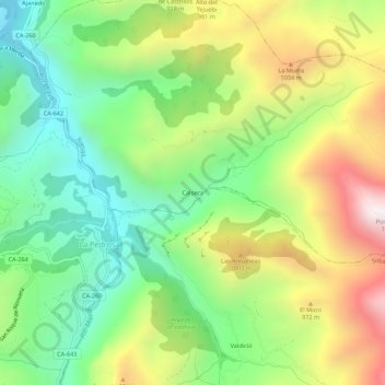
Name: Calseca topographic map, elevation, terrain.
Location: Calseca, Ruesga, Asón-Agüera, Cantabria, 39728, España (43.22070 -3.70934 43.26070 -3.66934)
Average elevation: 2,375 ft
Minimum elevation: 948 ft
Maximum elevation: 4,534 ft
Thank you for supporting this site ❤️
Make a donation
Make a donation
Gear up for your next adventure:
As an Amazon Associate, this site earns from qualifying purchases at no extra cost to you.