
Surfside topographic map
Click on the map to display elevation.
About this map
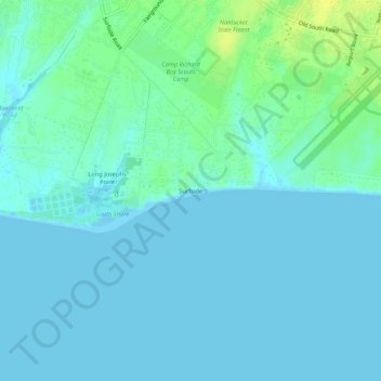
Name: Surfside topographic map, elevation, terrain.
Location: Surfside, Nantucket, Massachusetts, 02554, United States (41.22457 -70.10779 41.26457 -70.06779)
Average elevation: 13 ft
Minimum elevation: -3 ft
Maximum elevation: 56 ft
Massachusetts trails, hiking, mountain biking, running and outdoor activities
Other topographic maps
Click on a map to view its topography, its elevation and its terrain.