
Make a donation
Gear up for your next adventure:
As an Amazon Associate, this site earns from qualifying purchases at no extra cost to you.
Sorau topographic map
Click on the map to display elevation.
Make a donation
Gear up for your next adventure:
As an Amazon Associate, this site earns from qualifying purchases at no extra cost to you.
Sorau
Von 1888 bis 1945 gab es die Kaffeeservice und Tischgeschirr produzierende Porzellanfabrik Sorau. Das handbemalte Geschirr, meist mit Goldrand versehen, wurde nach Europa und Übersee exportiert. Der Elmshorner Kaufmann Christian Carstens erwarb die Porzellanfabrik 1919 und führte sie zum Höhepunkt ihrer Produktionszahlen mit der Fabrikmarke „Sorau Carstens Porzellan“ mit einer Krone und einem Lorbeerkranz. Noch in den 1950er Jahren galten die Sorauer Muster und Dekore als modern und wurden in der DDR von den VEB in Reichenbach und Blankenhain produziert.
Make a donation
Gear up for your next adventure:
As an Amazon Associate, this site earns from qualifying purchases at no extra cost to you.
About this map
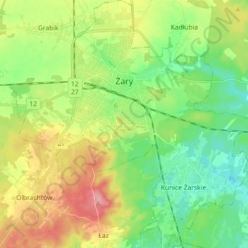
Name: Sorau topographic map, elevation, terrain.
Location: Sorau, powiat żarski, Woiwodschaft Lebus, Polen (51.58490 15.08293 51.66420 15.20796)
Average elevation: 528 ft
Minimum elevation: 397 ft
Maximum elevation: 758 ft
Make a donation
Gear up for your next adventure:
As an Amazon Associate, this site earns from qualifying purchases at no extra cost to you.