
Thank you for supporting this site ❤️
Make a donation
Make a donation
Gear up for your next adventure:
As an Amazon Associate, this site earns from qualifying purchases at no extra cost to you.
Fennange topographic map
Click on the map to display elevation.
Thank you for supporting this site ❤️
Make a donation
Make a donation
Gear up for your next adventure:
As an Amazon Associate, this site earns from qualifying purchases at no extra cost to you.
About this map
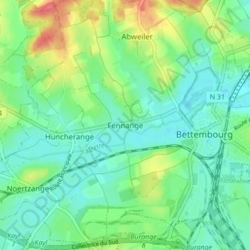
Name: Fennange topographic map, elevation, terrain.
Location: Fennange, Bettembourg, Canton Esch-sur-Alzette, 3332, Luxembourg (49.49876 6.05714 49.53876 6.09714)
Average elevation: 942 ft
Minimum elevation: 876 ft
Maximum elevation: 1,086 ft
Thank you for supporting this site ❤️
Make a donation
Make a donation
Gear up for your next adventure:
As an Amazon Associate, this site earns from qualifying purchases at no extra cost to you.