Geolocate

Ammon topographic map

Click on the map to display elevation.

About this map

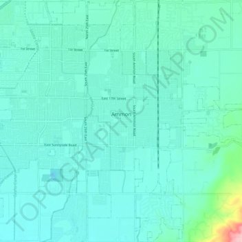
Name: Ammon topographic map, elevation, terrain.

Location: Ammon, Bonneville County, Idaho, 83406, United States (43.43882 -111.98452 43.51136 -111.89777)

Average elevation: 4,741 ft

Minimum elevation: 4,665 ft

Maximum elevation: 5,230 ft

Bonneville County trails, hiking, mountain biking, running and outdoor activities

Other topographic maps

Click on a map to view its topography, its elevation and its terrain.

Palisades

United States > Idaho > Bonneville County

Average elevation: 5,781 ft

Ririe Reservoir

United States > Idaho > Bonneville County

Average elevation: 5,643 ft

Mount Baldy

United States > Idaho > Bonneville County

Average elevation: 6,854 ft

Wheaton Mountain

United States > Idaho > Bonneville County

Average elevation: 6,086 ft

Chicken Peak

United States > Idaho > Bonneville County

Average elevation: 7,628 ft

Gear up for your next adventure:

🧭Map Reading Tools - Tools and kits for map navigation
🎒Day Hiking Backpack - Lightweight backpack perfect for day trips and outdoor adventures
🪶Wildlife Field Guides - Learn animal tracking and species ID
🧭GPS Watch Accessories - Bands and chargers for GPS watches
💧Water Purification System - Clean water on the trail with reliable purifiers

As an Amazon Associate, this site earns from qualifying purchases at no extra cost to you.