
Make a donation
Gear up for your next adventure:
As an Amazon Associate, this site earns from qualifying purchases at no extra cost to you.
Garden City topographic map
Click on the map to display elevation.
Make a donation
Gear up for your next adventure:
As an Amazon Associate, this site earns from qualifying purchases at no extra cost to you.
About this map
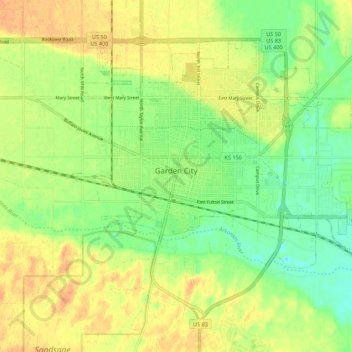
Name: Garden City topographic map, elevation, terrain.
Location: Garden City, Finney County, Kansas, 67846, United States (37.93694 -100.90168 38.00357 -100.79251)
Average elevation: 2,854 ft
Minimum elevation: 2,795 ft
Maximum elevation: 2,907 ft
Finney County trails, hiking, mountain biking, running and outdoor activities
Make a donation
Gear up for your next adventure:
As an Amazon Associate, this site earns from qualifying purchases at no extra cost to you.
Other topographic maps
Click on a map to view its topography, its elevation and its terrain.
Garden City
United States > Kansas > Finney County > Garden City > Garden City
Average elevation: 2,894 ft