
Thank you for supporting this site ❤️
Make a donation
Make a donation
Gear up for your next adventure:
As an Amazon Associate, this site earns from qualifying purchases at no extra cost to you.
Quitumba topographic map
Click on the map to display elevation.
Thank you for supporting this site ❤️
Make a donation
Make a donation
Gear up for your next adventure:
As an Amazon Associate, this site earns from qualifying purchases at no extra cost to you.
About this map
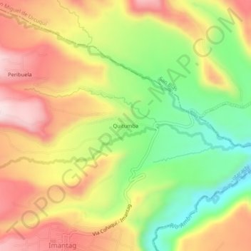
Name: Quitumba topographic map, elevation, terrain.
Location: Quitumba, Imantag, Cotacachi, Imbabura, 100216, Ecuador (0.35669 -78.25950 0.39669 -78.21950)
Average elevation: 7,520 ft
Minimum elevation: 6,785 ft
Maximum elevation: 8,219 ft
Thank you for supporting this site ❤️
Make a donation
Make a donation
Gear up for your next adventure:
As an Amazon Associate, this site earns from qualifying purchases at no extra cost to you.