
Thank you for supporting this site ❤️
Make a donation
Make a donation
Gear up for your next adventure:
As an Amazon Associate, this site earns from qualifying purchases at no extra cost to you.
Cappelletta topographic map
Click on the map to display elevation.
Thank you for supporting this site ❤️
Make a donation
Make a donation
Gear up for your next adventure:
As an Amazon Associate, this site earns from qualifying purchases at no extra cost to you.
About this map
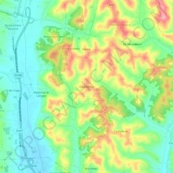
Name: Cappelletta topographic map, elevation, terrain.
Location: Cappelletta, Portacomaro, Asti, Piemonte, 14037, Italia (44.92330 8.22708 44.96330 8.26708)
Average elevation: 554 ft
Minimum elevation: 390 ft
Maximum elevation: 804 ft
Thank you for supporting this site ❤️
Make a donation
Make a donation
Gear up for your next adventure:
As an Amazon Associate, this site earns from qualifying purchases at no extra cost to you.