
Thank you for supporting this site ❤️
Make a donation
Make a donation
Gear up for your next adventure:
As an Amazon Associate, this site earns from qualifying purchases at no extra cost to you.
Keene topographic map
Click on the map to display elevation.
Thank you for supporting this site ❤️
Make a donation
Make a donation
Gear up for your next adventure:
As an Amazon Associate, this site earns from qualifying purchases at no extra cost to you.
About this map
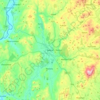
Name: Keene topographic map, elevation, terrain.
Location: Keene, Cheshire County, New Hampshire, 03435, United States (42.77360 -72.43843 43.09360 -72.11843)
Average elevation: 1,030 ft
Minimum elevation: 194 ft
Maximum elevation: 3,114 ft
Cheshire County trails, hiking, mountain biking, running and outdoor activities
Thank you for supporting this site ❤️
Make a donation
Make a donation
Gear up for your next adventure:
As an Amazon Associate, this site earns from qualifying purchases at no extra cost to you.