
Make a donation
Gear up for your next adventure:
As an Amazon Associate, this site earns from qualifying purchases at no extra cost to you.
Schaumberg topographic map
Click on the map to display elevation.
Make a donation
Gear up for your next adventure:
As an Amazon Associate, this site earns from qualifying purchases at no extra cost to you.
Schaumberg
Der Schaumberg ist ein Berg im Saarland und die höchste Erhebung im Naturraum Prims-Blies-Hügelland. Der Berg ist ein Kegelberg vulkanischen Ursprungs. Mit einer Höhe von 568,2 m und dem aufgesetzten markanten Schaumbergturm ist er aus weiter Entfernung sichtbar und gilt als „Hausberg des Saarlandes“, auch in der Tradition, dass er der höchste Berg des ehemaligen Saargebiets war. Er befindet sich im Landkreis St. Wendel in der Gemeinde Tholey zwischen den Orten Tholey und Theley.
Make a donation
Gear up for your next adventure:
As an Amazon Associate, this site earns from qualifying purchases at no extra cost to you.
About this map
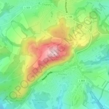
Name: Schaumberg topographic map, elevation, terrain.
Average elevation: 1,329 ft
Minimum elevation: 1,014 ft
Maximum elevation: 1,860 ft
Make a donation
Gear up for your next adventure:
As an Amazon Associate, this site earns from qualifying purchases at no extra cost to you.
Other topographic maps
Click on a map to view its topography, its elevation and its terrain.