
Make a donation
Gear up for your next adventure:
As an Amazon Associate, this site earns from qualifying purchases at no extra cost to you.
Blockland topographic map
Click on the map to display elevation.
Make a donation
Gear up for your next adventure:
As an Amazon Associate, this site earns from qualifying purchases at no extra cost to you.
Blockland
Das Blockland ist ein Landschaftsraum, der überwiegend durch flaches Marschland mit einer Höhe von 0,7 bis 1,8 m ü. NN geprägt ist. Es gehört zur Wümmeniederung. Ohne Deiche würden weite Flächen bei jeder Flut überschwemmt werden. Der Ortsteil wird nördlich und westlich begrenzt durch den Unterlauf (Tidengewässer) der Wümme und durch die Lesum, südwestlich durch das Maschinenfleet bzw. die Autobahn A 27 und die Bremer Düne und südöstlich durch den Kuhgraben. Der östliche Teil zwischen dem Weg Südwenje und dem Kuhgraben wird Wetterung genannt (in diesem Fall also keine Gewässerbezeichnung).
Make a donation
Gear up for your next adventure:
As an Amazon Associate, this site earns from qualifying purchases at no extra cost to you.
About this map
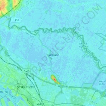
Name: Blockland topographic map, elevation, terrain.
Location: Blockland, Bremen-West, Bremen, Deutschland (53.11525 8.72255 53.17190 8.86454)
Average elevation: 10 ft
Minimum elevation: -7 ft
Maximum elevation: 128 ft
Make a donation
Gear up for your next adventure:
As an Amazon Associate, this site earns from qualifying purchases at no extra cost to you.
Other topographic maps
Click on a map to view its topography, its elevation and its terrain.
Make a donation
Gear up for your next adventure:
As an Amazon Associate, this site earns from qualifying purchases at no extra cost to you.