Geolocate

Lonos topographic map

Click on the map to display elevation.

About this map

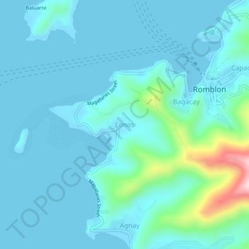
Name: Lonos topographic map, elevation, terrain.

Location: Lonos, Romblon, Mimaropa, 5500, Philippines (12.55012 122.23597 12.59012 122.27597)

Average elevation: 131 ft

Minimum elevation: 0 ft

Maximum elevation: 1,040 ft

Other topographic maps

Click on a map to view its topography, its elevation and its terrain.

Alad

Philippines > Romblon > Romblon

Average elevation: 33 ft

Logbon Island

Philippines > Romblon > Romblon > Logbon

Average elevation: 10 ft

Gear up for your next adventure:

🛠️Backpacking Tool Kit - Essential toolkit for outdoor repairs
🏕️Tent Footprint - Protect your tent base from wear
🧭Pro Hiking Compasses - High-accuracy liquid-filled compasses for topographic orientation
🔭Stargazing Telescopes - Perfect for camping in low-light pollution areas shown on maps
🌄Hiking Binoculars - Compact binoculars for scenic views and trail spotting

As an Amazon Associate, this site earns from qualifying purchases at no extra cost to you.