
Make a donation
Gear up for your next adventure:
As an Amazon Associate, this site earns from qualifying purchases at no extra cost to you.
Weinsheim topographic map
Click on the map to display elevation.
Make a donation
Gear up for your next adventure:
As an Amazon Associate, this site earns from qualifying purchases at no extra cost to you.
About this map
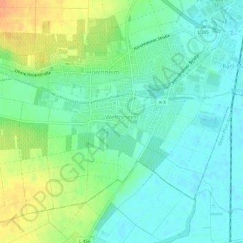
Name: Weinsheim topographic map, elevation, terrain.
Location: Weinsheim, Vororte Südwest, Worms, Rheinland-Pfalz, Deutschland (49.59323 8.30676 49.61591 8.35302)
Average elevation: 338 ft
Minimum elevation: 295 ft
Maximum elevation: 417 ft
Make a donation
Gear up for your next adventure:
As an Amazon Associate, this site earns from qualifying purchases at no extra cost to you.
Other topographic maps
Click on a map to view its topography, its elevation and its terrain.
Worms
Deutschland > Rheinland-Pfalz > Worms
Das langjährige Mittel der Lufttemperatur des Zeitraums 1951 bis 1980 beträgt 10,3 °C. In den vergangenen Jahren wurde eine Steigerung des Jahresmittels der Lufttemperatur beobachtet. So betrug im Jahr 2008 die gemittelte Lufttemperatur an der Hagenstraße 12,2 °C, während im gleichen Zeitraum fünf…
Average elevation: 328 ft