Geolocate

Frauenstein topographic map

Click on the map to display elevation.

About this map

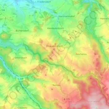
Name: Frauenstein topographic map, elevation, terrain.

Location: Frauenstein, Mittelsachsen, Saxony, Germany (50.74230 13.44617 50.84622 13.57944)

Average elevation: 1,949 ft

Minimum elevation: 1,476 ft

Maximum elevation: 2,651 ft

Other topographic maps

Click on a map to view its topography, its elevation and its terrain.

Clausnitz

Germany > Saxony > Mittelsachsen

Average elevation: 1,998 ft

Holzhau

Germany > Saxony > Mittelsachsen

Average elevation: 2,379 ft

Seifersdorf

Germany > Saxony > Mittelsachsen > Hartha

Average elevation: 814 ft

Tuttendorf

Germany > Saxony > Mittelsachsen

Average elevation: 1,234 ft

Dittmannsdorf

Germany > Saxony > Mittelsachsen > Penig

Average elevation: 820 ft

Erdmannsdorf

Germany > Saxony > Mittelsachsen > Augustusburg

Average elevation: 1,234 ft

Hühnerberg

Germany > Saxony > Mittelsachsen > Leisnig

Average elevation: 686 ft

Gear up for your next adventure:

🎒Gear Packing Cubes - Organize your backpack efficiently
🦶Hiking Gaiters - Keep debris and water out of your boots
🔦Powerful Headlamps - Ultra-bright hands-free lighting for night navigation
🪶Wildlife Field Guides - Learn animal tracking and species ID
🛡️Insect Repellent - Protection against bugs during outdoor activities

As an Amazon Associate, this site earns from qualifying purchases at no extra cost to you.