Geolocate

Jipapad topographic map

Click on the map to display elevation.

About this map

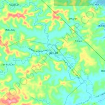
Name: Jipapad topographic map, elevation, terrain.

Location: Jipapad, Eastern Samar, Eastern Visayas, 6804, Philippines (12.24607 125.19529 12.32607 125.27529)

Average elevation: 151 ft

Minimum elevation: 7 ft

Maximum elevation: 486 ft

Gear up for your next adventure:

🧯Portable Fire Pit - Compact fire pit for camping spots
🔌USB Car Charger - Car charger for on‑the‑go power needs
📻Weather Alert Radios - Stay informed of storm risks while off-the-grid
Backpacking Tent - Lightweight and durable tent for multi‑day hikes
🔭Compact Binoculars - HD vision for scouting terrain and identifying distant landmarks

As an Amazon Associate, this site earns from qualifying purchases at no extra cost to you.