Geolocate

Abuleg topographic map

Click on the map to display elevation.

About this map

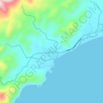
Name: Abuleg topographic map, elevation, terrain.

Location: Abuleg, Dinalungan, Aurora, Central Luzon, Philippines (16.09868 121.83908 16.13868 121.87908)

Average elevation: 207 ft

Minimum elevation: 0 ft

Maximum elevation: 1,253 ft

Gear up for your next adventure:

🚁Photography Drones - Capture stunning aerial views of landforms and topography
🧭Outdoor Navigation Book - Learn advanced navigation skills
🪶Camping Sleeping Pad - Comfortable sleeping pad for backpacking
🪓Survival Multi‑Tool - Versatile tool for camp and trail tasks
Solar GPS Watches - Advanced multisport watches with built-in topographic maps

As an Amazon Associate, this site earns from qualifying purchases at no extra cost to you.