
Make a donation
Gear up for your next adventure:
As an Amazon Associate, this site earns from qualifying purchases at no extra cost to you.
Muizen topographic map
Click on the map to display elevation.
Make a donation
Gear up for your next adventure:
As an Amazon Associate, this site earns from qualifying purchases at no extra cost to you.
Muizen
Muizen ligt in Droog-Haspengouw, in de vallei van de Cicindria, welke van zuid naar noord stroomt. Op de Muizenberg ligt de Heilig-Kruiskapel. De hoogte bedraagt ongeveer 80 meter.
Make a donation
Gear up for your next adventure:
As an Amazon Associate, this site earns from qualifying purchases at no extra cost to you.
About this map
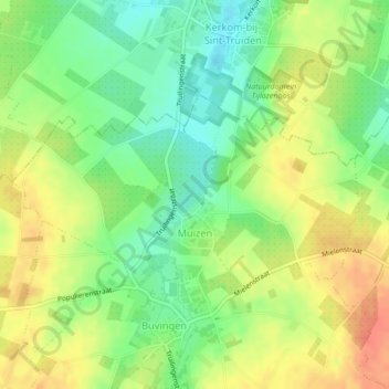
Name: Muizen topographic map, elevation, terrain.
Location: Muizen, Gingelom, Hasselt, Limburg, België (50.75494 5.15846 50.76881 5.19652)
Average elevation: 292 ft
Minimum elevation: 213 ft
Maximum elevation: 371 ft
Make a donation
Gear up for your next adventure:
As an Amazon Associate, this site earns from qualifying purchases at no extra cost to you.
Other topographic maps
Click on a map to view its topography, its elevation and its terrain.
Make a donation
Gear up for your next adventure:
As an Amazon Associate, this site earns from qualifying purchases at no extra cost to you.