
Make a donation
Gear up for your next adventure:
As an Amazon Associate, this site earns from qualifying purchases at no extra cost to you.
Maxwell topographic map
Click on the map to display elevation.
Make a donation
Gear up for your next adventure:
As an Amazon Associate, this site earns from qualifying purchases at no extra cost to you.
Maxwell
Maxwell (formerly, Occident) is a census-designated place and farm community in Colusa County, California. It lies at an elevation of 92 feet (28 m). Located off Interstate 5, it is home to Maxwell High School. The main crop grown is rice, though a variety of others such as grapes, almonds, olives, squash, and sunflowers are grown as well. Its ZIP code is 95955 and its area code is 530. Maxwell's population was 1,103 at the 2010 census.
Make a donation
Gear up for your next adventure:
As an Amazon Associate, this site earns from qualifying purchases at no extra cost to you.
About this map
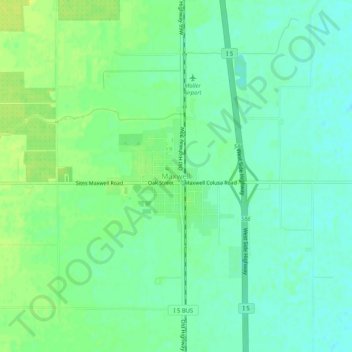
Name: Maxwell topographic map, elevation, terrain.
Location: Maxwell, Colusa County, California, 95955, United States (39.25700 -122.21241 39.29700 -122.17241)
Average elevation: 89 ft
Minimum elevation: 62 ft
Maximum elevation: 118 ft
Colusa County trails, hiking, mountain biking, running and outdoor activities
Make a donation
Gear up for your next adventure:
As an Amazon Associate, this site earns from qualifying purchases at no extra cost to you.
Other topographic maps
Click on a map to view its topography, its elevation and its terrain.