
Make a donation
Gear up for your next adventure:
As an Amazon Associate, this site earns from qualifying purchases at no extra cost to you.
Beaune topographic map
Click on the map to display elevation.
Make a donation
Gear up for your next adventure:
As an Amazon Associate, this site earns from qualifying purchases at no extra cost to you.
About this map
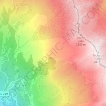
Name: Beaune topographic map, elevation, terrain.
Average elevation: 6,739 ft
Minimum elevation: 3,491 ft
Maximum elevation: 9,239 ft
Make a donation
Gear up for your next adventure:
As an Amazon Associate, this site earns from qualifying purchases at no extra cost to you.
Other topographic maps
Click on a map to view its topography, its elevation and its terrain.
Le Noiray
France > Auvergne-Rhône-Alpes > Savoie > Saint-Michel-de-Maurienne
Average elevation: 3,579 ft
Le Mollard
France > Auvergne-Rhône-Alpes > Savoie > Saint-Michel-de-Maurienne
Average elevation: 4,656 ft
La Traversaz
France > Auvergne-Rhône-Alpes > Savoie > Saint-Michel-de-Maurienne
Average elevation: 4,298 ft
La Saussaz
France > Auvergne-Rhône-Alpes > Savoie > Saint-Michel-de-Maurienne
Average elevation: 3,937 ft
Make a donation
Gear up for your next adventure:
As an Amazon Associate, this site earns from qualifying purchases at no extra cost to you.
La Buffaz
France > Auvergne-Rhône-Alpes > Savoie > Saint-Michel-de-Maurienne
Average elevation: 3,947 ft
Les Fontaines
France > Auvergne-Rhône-Alpes > Savoie > Saint-Michel-de-Maurienne
Average elevation: 3,878 ft
Le Mollard
France > Auvergne-Rhône-Alpes > Savoie > Saint-Michel-de-Maurienne
Average elevation: 3,458 ft
Les Teppes
France > Auvergne-Rhône-Alpes > Savoie > Saint-Michel-de-Maurienne
Average elevation: 3,468 ft
Make a donation
Gear up for your next adventure:
As an Amazon Associate, this site earns from qualifying purchases at no extra cost to you.
Le Mollard
France > Auvergne-Rhône-Alpes > Savoie > Saint-Michel-de-Maurienne
Average elevation: 4,656 ft