
Lakeside topographic map
Click on the map to display elevation.
About this map
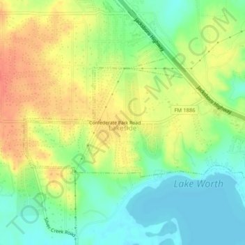
Name: Lakeside topographic map, elevation, terrain.
Location: Lakeside, Tarrant County, Texas, United States (32.81553 -97.50909 32.83053 -97.46932)
Average elevation: 673 ft
Minimum elevation: 594 ft
Maximum elevation: 761 ft
Tarrant County trails, hiking, mountain biking, running and outdoor activities
Other topographic maps
Click on a map to view its topography, its elevation and its terrain.
Summerfields/Chisholm Park
United States > Texas > Tarrant County > Fort Worth
Average elevation: 666 ft
Will Rogers Memorial Center
United States > Texas > Tarrant County > Fort Worth
Average elevation: 594 ft
La Frontera
United States > Texas > Tarrant County > Arlington > La Frontera
Average elevation: 607 ft