
Short Pump topographic map
Click on the map to display elevation.
About this map
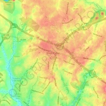
Name: Short Pump topographic map, elevation, terrain.
Location: Short Pump, Henrico County, Virginia, 23233, United States (37.61061 -77.65195 37.69061 -77.57195)
Average elevation: 236 ft
Minimum elevation: 105 ft
Maximum elevation: 331 ft
Henrico County trails, hiking, mountain biking, running and outdoor activities
Other topographic maps
Click on a map to view its topography, its elevation and its terrain.
Canterbury Lake
United States > Virginia > Henrico County > Tuckahoe > Canterbury
Average elevation: 190 ft
Canterbury Dam
United States > Virginia > Henrico County > Tuckahoe > Canterbury
Average elevation: 187 ft