
Make a donation
Gear up for your next adventure:
As an Amazon Associate, this site earns from qualifying purchases at no extra cost to you.
McAdoo topographic map
Click on the map to display elevation.
Make a donation
Gear up for your next adventure:
As an Amazon Associate, this site earns from qualifying purchases at no extra cost to you.
McAdoo
According to the United States Census Bureau, the borough has a total area of 0.3 square miles (0.78 km2), all land. McAdoo's elevation is 1700 feet above sea level. It is on the crest of Broad Mountain and straddles the divide between the Delaware and Susquehanna watersheds. Pennsylvania Route 309 (Kennedy Drive) is the main north-to-south thoroughfare. Interstate 81 runs a short distance west of town and parallel to PA 309. The two routes have an access highway connecting them just south of McAdoo at exit 138 of I-81. McAdoo has a warm-summer humid continental climate (Dfb) and the hardiness zone is 6a. Average monthly temperatures range from 23.5 °F in January to 70.1 °F in July.
Make a donation
Gear up for your next adventure:
As an Amazon Associate, this site earns from qualifying purchases at no extra cost to you.
About this map
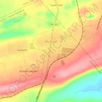
Name: McAdoo topographic map, elevation, terrain.
Average elevation: 1,732 ft
Minimum elevation: 1,460 ft
Maximum elevation: 1,903 ft
Schuylkill County trails, hiking, mountain biking, running and outdoor activities
Make a donation
Gear up for your next adventure:
As an Amazon Associate, this site earns from qualifying purchases at no extra cost to you.
Other topographic maps
Click on a map to view its topography, its elevation and its terrain.
Barnesville
United States > Pennsylvania > Schuylkill County > Rush Township
Average elevation: 1,175 ft
Park Place
United States > Pennsylvania > Schuylkill County > Mahanoy Township
Average elevation: 1,690 ft
Andreas
United States > Pennsylvania > Schuylkill County > West Penn Township
Average elevation: 820 ft
Mahanoy Plane
United States > Pennsylvania > Schuylkill County > Gilberton
Average elevation: 1,339 ft
Make a donation
Gear up for your next adventure:
As an Amazon Associate, this site earns from qualifying purchases at no extra cost to you.
Snyders
United States > Pennsylvania > Schuylkill County > West Penn Township
Average elevation: 794 ft
Blue Mountain
United States > Pennsylvania > Schuylkill County > Washington Township
The ridge of Blue Mountain runs for 150 miles (240 km) through Pennsylvania, reaching an elevation of 2,270 feet (690 m) above sea level just north of the Pennsylvania Turnpike, near the borough of Newburg. Most of the ridgecrest, however, only reaches between 1,400 and 1,700 feet (430 and 520 m) in elevation.…
Average elevation: 741 ft
Make a donation
Gear up for your next adventure:
As an Amazon Associate, this site earns from qualifying purchases at no extra cost to you.
Blue Mountain
United States > Pennsylvania > Schuylkill County > Washington Township
The ridge of Blue Mountain runs for 150 miles (240 km) through Pennsylvania, reaching an elevation of 2,270 feet (690 m) above sea level just north of the Pennsylvania Turnpike, near the borough of Newburg. Most of the ridgecrest, however, only reaches between 1,400 and 1,700 feet (430 and 520 m) in elevation.…
Average elevation: 741 ft
Irving
United States > Pennsylvania > Schuylkill County > Pine Grove Township
Average elevation: 653 ft
Andreas
United States > Pennsylvania > Schuylkill County > West Penn Township
Average elevation: 820 ft
Make a donation
Gear up for your next adventure:
As an Amazon Associate, this site earns from qualifying purchases at no extra cost to you.
Blue Mountain
United States > Pennsylvania > Schuylkill County > Washington Township
The ridge of Blue Mountain runs for 150 miles (240 km) through Pennsylvania, reaching an elevation of 2,270 feet (690 m) above sea level just north of the Pennsylvania Turnpike, near the borough of Newburg. Most of the ridgecrest, however, only reaches between 1,400 and 1,700 feet (430 and 520 m) in elevation.…
Average elevation: 741 ft
Nuremberg
United States > Pennsylvania > Schuylkill County > North Union Township
Average elevation: 1,237 ft