
Make a donation
Gear up for your next adventure:
As an Amazon Associate, this site earns from qualifying purchases at no extra cost to you.
Del Rio topographic map
Click on the map to display elevation.
Make a donation
Gear up for your next adventure:
As an Amazon Associate, this site earns from qualifying purchases at no extra cost to you.
About this map
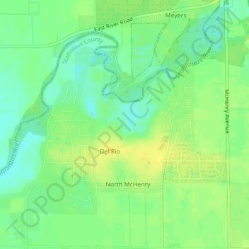
Name: Del Rio topographic map, elevation, terrain.
Location: Del Rio, Stanislaus County, California, United States (37.73279 -121.02431 37.76018 -120.99529)
Average elevation: 105 ft
Minimum elevation: 66 ft
Maximum elevation: 138 ft
Stanislaus County trails, hiking, mountain biking, running and outdoor activities
Make a donation
Gear up for your next adventure:
As an Amazon Associate, this site earns from qualifying purchases at no extra cost to you.
Other topographic maps
Click on a map to view its topography, its elevation and its terrain.
San Joaquin River National Wildlife Refuge
United States > California > Stanislaus County
Average elevation: 46 ft
Make a donation
Gear up for your next adventure:
As an Amazon Associate, this site earns from qualifying purchases at no extra cost to you.