
Thank you for supporting this site ❤️
Make a donation
Make a donation
Gear up for your next adventure:
As an Amazon Associate, this site earns from qualifying purchases at no extra cost to you.
Koi topographic map
Click on the map to display elevation.
Thank you for supporting this site ❤️
Make a donation
Make a donation
Gear up for your next adventure:
As an Amazon Associate, this site earns from qualifying purchases at no extra cost to you.
About this map
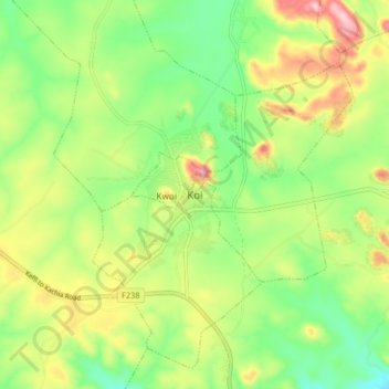
Name: Koi topographic map, elevation, terrain.
Location: Koi, Sabchem, Jaba, Kaduna State, Nigeria (9.41362 7.97057 9.49362 8.05057)
Average elevation: 2,523 ft
Minimum elevation: 2,221 ft
Maximum elevation: 2,966 ft
Thank you for supporting this site ❤️
Make a donation
Make a donation
Gear up for your next adventure:
As an Amazon Associate, this site earns from qualifying purchases at no extra cost to you.