Geolocate

Monroe topographic map

Click on the map to display elevation.

About this map

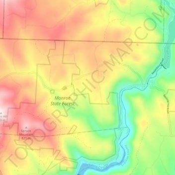
Name: Monroe topographic map, elevation, terrain.

Location: Monroe, Franklin County, Massachusetts, 01350, United States (42.70126 -73.02371 42.74114 -72.92719)

Average elevation: 1,814 ft

Minimum elevation: 827 ft

Maximum elevation: 2,818 ft

Franklin County trails, hiking, mountain biking, running and outdoor activities

Other topographic maps

Click on a map to view its topography, its elevation and its terrain.

Dell

United States > Massachusetts > Franklin County > Heath

Average elevation: 1,447 ft

Zoar

United States > Massachusetts > Franklin County > Charlemont

Average elevation: 1,096 ft

Adamsville

United States > Massachusetts > Franklin County > Colrain

Average elevation: 1,040 ft

Watson

United States > Massachusetts > Franklin County > Ashfield

Average elevation: 1,588 ft

Tully

United States > Massachusetts > Franklin County > Orange

Average elevation: 722 ft

Gear up for your next adventure:

👖Convertible Hiking Pants - Versatile zip-off pants for changing altitudes and temperatures
📱Heavy-Duty Phone Cases - Drop-proof and waterproof protection for outdoor navigation
🎒Trail Energy Bars - High‑calorie bars for hiking energy
🔦LED Headlamp - Bright and durable LED headlamp for night navigation
🦺Reflective Outdoor Gear - Safety gear for low‑light conditions

As an Amazon Associate, this site earns from qualifying purchases at no extra cost to you.