
Thank you for supporting this site ❤️
Make a donation
Make a donation
Gear up for your next adventure:
As an Amazon Associate, this site earns from qualifying purchases at no extra cost to you.
Tân Bình topographic map
Click on the map to display elevation.
Thank you for supporting this site ❤️
Make a donation
Make a donation
Gear up for your next adventure:
As an Amazon Associate, this site earns from qualifying purchases at no extra cost to you.
About this map
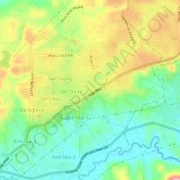
Name: Tân Bình topographic map, elevation, terrain.
Location: Tân Bình, Phường 3 Bảo Lộc, Lâm Đồng Province, Vietnam (11.51215 107.75823 11.55215 107.79823)
Average elevation: 2,631 ft
Minimum elevation: 2,434 ft
Maximum elevation: 2,917 ft
Thank you for supporting this site ❤️
Make a donation
Make a donation
Gear up for your next adventure:
As an Amazon Associate, this site earns from qualifying purchases at no extra cost to you.